- Joined
- May 6, 2008
- Messages
- 63,909
- Reaction score
- 28,896
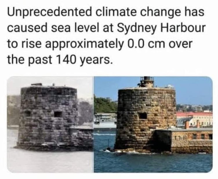
There are many versions of this argument (particularly popular ones include the Plymouth Stone, Palm Beach Florida, and various bridges), but they all suffer the same fundamental problem, so there is no need to harp on specifics (with one exception discussed later).
The core problem here is that the photos don’t take into account several critical factors, such as tides. The sea level is not static. It goes up and down twice every day, in some places quite dramatically. Further, the timing of peak high and peak low tides shifts from one day to the next, and the magnitude of the tides changes throughout the year. This means that the sea level at any one location is constantly changing. As a result, two photos of the same spot at two different time points are completely meaningless. If, for example, the old photo was at high tide and the recent photo was at low tide, it is going to look like there was no change in sea level, but that’s clearly a bad comparison because the tides were different! You can’t just ignore the existence of tides.

Beryl’s arrival marks an exceptionally early start to the Atlantic hurricane season. On Sunday it became the earliest Category 4 on record in the Atlantic Ocean and the only Category 4 in the month of June. The abnormally warm ocean waters that facilitated Beryl’s alarming strengthening are a clear indicator that this hurricane season will be far from normal in a world warming due to fossil fuel pollution.
You can literally see what level the sea gets up to during high tide in the last picture but looking at the difference in colour of the stones.
OK, so we can put you down for buying it.
For buying what? You can clearly see the line where the high ride rises too and if you'd had to compare if to the older photo I'd estimate the shoreline went up the height of about 4 bricks. Which lines up with the 8-9 inches another poster claimed is how much the sea level has risen during that time.
As it happens, here in Atlantic Canada, the temp today and tomorrow will only be in the high twenties Celsius but with the humidity it will feel like 35-40. On the local radio news this morning they reported that last month was the hottest June on record. It hardly ever got that hot when I was a kid and now it happens all the time.Heatstroke alerts issued across Japan as heatwave leads to four deaths
Average number of heatstroke-related deaths each year has increased six fold since 1995
Japan’s meteorological agency has issued a heatstroke alert for 26 of the country’s 47 prefectures, urging people not to go outside unless absolutely necessary, to use their air conditioners during the day and at night, and to drink plenty of water.
Authorities in Japan issued the extreme heat warnings after the temperature reached 40C for the first time this year on Sunday, as the country swelters in the grip of another heatwave.
Shizuoka in central Japan reported a temperature of 40C in the early afternoon on Sunday, while 244 other locations saw the mercury rise to 35C or over – a level officially recognised as “extremely hot”.
The temperature in Shizuoka, recorded shortly after 1 pm, was the highest in the city since records began in 1940, according to the Japan Times.
The meteorological agency warned earlier this year that temperatures are expected to be higher than average again this summer, perhaps exceeding those last summer – the hottest on record.
Hot and humid summers are normal in Japan , particularly after the rainy season ends in mid- to late July, but temperatures have been particularly high in recent years as a result of global heating and other climatic factors, according to experts.
There is particular concern for the welfare of the country’s large older population, who are more vulnerable to heatstroke. The fire and disaster management agency said that of the 2,276 people were taken to hospital for heatstroke in the last week of June, more than half were aged over 65.
Young children are also at risk. This month firefighters were called out in Kyoto after nine children showed symptoms of heatstroke during a school trip. Three were taken to hospital, according to public broadcaster NHK, which warned that temperatures had reached “life-threatening” levels.
At least four deaths associated with the weather have been reported in recent days: a man in his 70s who was found dead at his home after cutting the grass, and another in his 80s who had been working on his farm. On Sunday, media reported that a woman in her 90s was pronounced dead after collapsing at home, while an 83-year-old woman died after working outside.
In Tokyo, 198 people were taken to hospital with suspected heatstroke on Sunday, NHK said. The temperature in some parts of the city had reached at least 35C by mid-morning on Monday.
Statistics from the health ministry reported by the Japan Times show that the number of heatstroke-related deaths increased from an average of 201 people a year between 1995 and 1999, to an average of 1,295 from 2018 to 2022. Between 80 and 90% of those who die are over 65, according to data cited by the newspaper.
The maximum recorded temperature in Japan was 41.1°C in the central city of Hamamatsu on August 17, 2020, and in Kumagaya, north-west of Tokyo, on July, 23, 2018.
https://www.theguardian.com/world/a...heatstroke-alerts-heatwave-weather-death-toll
- First time i felt a 37 graus temperature was eight years or so ago. Theres were dogs faiting because of the heat. A guy died playing soccer.As it happens, here in Atlantic Canada, the temp today and tomorrow will only be in the high twenties Celsius but with the humidity it will feel like 35-40. On the local radio news this morning they reported that last month was the hottest June on record. It hardly ever got that hot when I was a kid and now it happens all the time.
"Oceans have absorbed 90 percent of the excess heat produced by human activity since the dawn of the industrial age, according to scientists."Mediterranean Sea reaches highest surface temperature ever recorded
The Mediterranean Sea reached its highest surface temperature with a daily median of 28.9 degrees Celsius on Thursday, according to Spanish researchers, topping a previous record set last month. For two successive summers, the Mediterranean has been warmer than it was during the exceptional 2003 heatwave, when temperatures hit record highs that went unchallenged for 20 years.
The Mediterranean Sea reached its highest temperature on record Thursday, Spanish researchers told AFP on Friday, breaking the record from July 2023.
"The maximum sea surface temperature record was broken in the Mediterranean Sea yesterday... with a daily median of 28.90C," Spain's leading institute of marine sciences said.
The previous record occurred on July 24, 2023, with a median value of 28.71C, said Justino Martinez, researcher at the Institut de Ciencies del Mar in Barcelona and the Catalan Institute of Research for the Governance of the Sea.
"The maximum temperature on August 15 was attained on the Egyptian coast at El-Arish (31.96C)," but this value is preliminary until further human checks can be carried out, he added.
The preliminary readings for 2024 come from satellite data from the European Copernicus Observatory, with records dating back to 1982.
It means that for two successive summers the Mediterranean will have been warmer than during the exceptional summer heatwave of 2003, when a daily median was measured at 28.25C on August 23, a record that had stood for twenty years.
"What is remarkable is not so much to reach a maximum on a given day, but to observe a long period of high temperatures, even without breaking a record," Martinez told AFP earlier this week.
"Since 2022, surface temperatures have been abnormally high for long periods, even in a climate-change environment," he said.
The Mediterranean region has long been classified as a hotspot of climate change.
Oceans have absorbed 90 percent of the excess heat produced by human activity since the dawn of the industrial age, according to scientists.
This excess heat continues to accumulate as greenhouse gases, mainly from burning oil, gas and coal.
The overheating of the oceans is predicted to impact marine plant and animal life, including on the migration of certain species and the spread of invasive species.
This could threaten fish stocks and thus undermine food security in certain parts of the globe.
Warmer oceans are also less capable of absorbing carbon dioxide (CO2), reinforcing the vicious cycle of global warming.
https://www.france24.com/en/europe/...face-temperature-ever-recorded-climate-change
- The sharks attacks are increasing also:"Oceans have absorbed 90 percent of the excess heat produced by human activity since the dawn of the industrial age, according to scientists."
This part is what I think should be most concerning. Even if massive cuts in greenhouse gas production are realised soon, it will take a long time to see much effect while the oceans give up that stored heat back into the atmosphere to approach equilibrium.
I think it's already far too late to prevent some pretty awful disasters, so it's all the more reason to try to reduce greenhouse gas production as much as we possibly can. Not gonna happen though, by the look of it. Sad.
That's quite the winter.Red centre heat could see temperature records tumble across Australia in coming days, meteorologists forecast
Hot winds predicted to push temperatures four to seven degrees above average across the east of the country
Potentially record-breaking winter heat in Australia’s centre will carry unseasonably warm temperatures across the country this weekend and into the next week, meteorologists predict.
Temperatures across most of the country except the very far west, will sit four to seven degrees above average, including most urban centres in Victoria, New South Wales, Queensland and Tasmania, said Angus Hines, a senior meteorologist at the bureau of meteorology.
Weatherzone has predicted temperatures in most south-eastern capitals will be exceptionally warm for winter on Sunday. It is forecasting 25C in Sydney, 24C in Adelaide, 23C in Melbourne, 21C in Canberra and 19C in Hobart.
Foreshadowing the weekend’s spike in heat, Sydney could reach 26C on Wednesday, eight degrees higher than the average August temperatures of 18C.
The reason for the predicted unseasonal spike, meteorologists say, is a strong high pressure system set to generate record August temperatures in the middle of the country.
Winds will then carry that heat out to other parts of the country.
Alice Springs is forecast to hit 35C on Friday, Saturday and Sunday, and may break its record August temperature of 35.2C, Weatherzone says.
South Australian towns in the north of the state may also see records tumble, with Coober Pedy predicted to hit 34C on Saturday – close to its winter record of 34.3. Meanwhile, Oodnadatta is tipped to reach 36C on Friday and Saturday, very close to its winter record of 36.5C.
Hines said the forecast maximum temperatures through southern Northern Territory and northern South Australia would get very close to the warmest on record in August.
“Saturday looks to be probably the warmest day and maybe Sunday we could get close to some records as well,” he said.
“It’s very hard to forecast records in advance, but the temperatures we’re forecasting are … as high as they get pretty much, so [it is] definitely possible we’ll see some records.”
The warmer conditions building in Australia’s centre over the coming days “will get pulled eastwards as the wind starts to shift,” he said.
“It’s going to be above average for the time of year almost everywhere, particularly as we get towards the end of this week and into the weekend.”
Weatherzone said “no records” are likely to be broken in the south due to a relatively weak cold front clipping the south-east, “but it will still feel decidedly un-wintry this coming weekend, which is the last full weekend of winter.”
Jiwon Park, also with the bureau of meteorology, said the unseasonal heat is already developing in the Top End and much of the pastoral parts of South Australia, Northern Territory and Western Queensland.
https://www.theguardian.com/austral...tralia-in-coming-days-meteorologists-forecast

 www.wickedlocal.com