• Xenforo is upgrading us to version 2.3.7 on Tuesday Aug 19, 2025 at 01:00 AM BST (date has been pushed). This upgrade includes several security fixes among other improvements. Expect a temporary downtime during this process. More info here

POTWR 2019 Vol 11: Can We All Test For Ourselves That The Earth Is Round?

Status
Not open for further replies.
Maybe I don't understand what exactly you are asking for. Following the latitudal lines like @Cubo de Sangre was talking about. NY west to HI and west to JPN. NY east to UAE, east to JPN.

fjjiFpF.jpg


Red line is shorter than the purple so the 2.5k mile difference makes sense. Even if you straighten the lines it still works. Count the long and lat grid squares, roughly 5-5.5 squares for either HI or UAE

Someone should just book the flat Earth route and fly over Antarctica just to put the baby to bed. Tourists would eat that up. Sell 'em some high-priced "duty-free" shit.

https://en.wikipedia.org/wiki/Polar_route

Few airlines fly between cities having a great circle route over Antarctica. Nonstop flights between South Africa and New Zealand, or between Perth, Australia and certain destinations in South America (including Buenos Aires and São Paulo), would overfly Antarctica, but no airline has scheduled such flights.

Flights between Australia and South America and between Australia and South Africa pass near the Antarctic coastline. Depending on the winds, the Qantas flight QFA63 from Sydney to Johannesburg-O. R. Tambo, or the return flight QFA64, sometimes flies over the Antarctic Circle to 71° latitude as well and allowing views of the icecap.[17] Qantas QFA27 and QFA28 fly nonstop between Sydney and Santiago de Chile, the most southerly polar route. Depending on winds, this flight may reach 55° south latitude, but other times 71°, which is enough to cross the polar ice cap.[18][better source needed] Previously, QANTAS also operated QFA17 and QFA18 between Sydney, Australia and Buenos Aires, Argentina. Nowadays, LATAM operates LAN804 and LAN805 between Melbourne, Australia, and Santiago, Chile, and Air New Zealand operates ANZ30 and ANZ31 between Auckland, New Zealand and Buenos Aires, Argentina all with similarly south-running routes.

The polar route across the remote southern Pacific Ocean between South America and Oceania was pioneered by Aerolineas Argentinas, which began service between Buenos Aires via Rio Gallegos to Auckland in the 1980s with a Boeing 747-200 aircraft. Aerolineas Argentinas later operated to Sydney, but ended its flights to New Zealand and Australia in 2014.[19]

Because of ETOPS limitations on twin-engined aircraft—the maximum distance the aircraft can operate from an airport for emergency landings—only four-engined aircraft such as the Boeing 747, Airbus A340, and Airbus A380 can or could operate routes near Antarctica. Twin-engined aircraft must fly further north, closer to potential diversion airports; for example, when Virgin Australia operated their VA 15 and VA 16 flights between Melbourne and Johannesburg on twin-engined Boeing 777 aircraft with a 180-minute ETOPS rating, the flight was two hours longer than a Qantas flight from Sydney to Johannesburg.[20] Air New Zealandflight ANZ30 and ANZ31 flies nonstop between Auckland and Buenos Aires-Ezeiza; in 2015, government regulators approved its twin-engined Boeing 777-200ER aircraft that operate the route for a 330-minute ETOPS rating (i.e. its 777 aircraft can fly a maximum 330 minutes away from the nearest diversion airport), an increase from its previous 240-minute ETOPS rating.[21] LATAM Airlines began their LAN800 and LAN801 nonstop flights between Santiago de Chile and Sydney via Auckland in April 2015 with twin-engined Boeing 787 aircraft with a 330-minute ETOPS rating.[22][23] LATAM has announced a nonstop flight between Santiago de Chile and Melbourne to begin in October 2017.[24][25]

The southernmost flight route with plausible airports would be between Buenos Aires and Perth.[26] With a 175° (S) heading, the route's great circle exceeds 85° S and would be within 310 miles (500 km) from the South Pole. Currently, no commercial airliners operates this 6,800-nautical-mile (7,800 mi; 12,600 km) route. However, in February, 2018, it was stated that Norwegian Air Argentina is considering this "less than 15 hours" trans-polar flight between South America and Asia, with a stop-over in Perth enroute Singapore.[27] They will not fly over the South Pole, but around Antarctica taking advantage of the strong winds which circle that continent in an easterly direction. Hence, the "westbound" flight from Buenos Aires would actually travel south-east south of Cape Town, over the southern Indian Ocean and on to Perth, while the true "eastbound" flight would also head south-east south of Tasmania and New Zealand, over the South Pacific and on to South America. If this route becomes operational, a Buenos Aires - Singapore return flight would possibly be the fastest circumnavigation available with commercial airliners, although Perth - Buenos Aires return would be faster but without passing the Equator.
 
The flight path stuff offered by @MikeMcMann has been put to rest, but y'all keep skipping over his other point.

His point was that if the planet spins as we are told why are there no significant differences in air travel times?

Anyone?
 
The flight path stuff offered by @MikeMcMann has been put to rest, but y'all keep skipping over his other point.

His point was that if the planet spins as we are told why are there no significant differences in air travel times?

Anyone?

Atmosphere. It moves with the earth. An object in motion stays in motion. Same reason you don't run, drive, etc faster one way vs the other. Same reason when you jump you land right back down where you started. Same reason you can walk back and forth in a plane traveling 560 mph at the same speed & stride length.

Jet stream/wind has a great effect on travel time. and those are created by coriolis effect. So depending on wind/jet stream there can be a significant difference in travel speed. A couple months ago a plane with an air speed of roughly 560 mph hit 801 mph ground speed due to tail wind.
 
Congrats you have drawn the failure I've been speaking of and you can do it for any singular location any where in the world.

You destroy your own logic when you acknowledge Hawaii is a point West of NYC but you have to continue West beyond that to get to Japan and also admit Dubai is a point East of NYC and you have to continue farther East to get to Japan but then when you draw in Japan you place it EAST of Hawaii and WEST of Dubai.

It is a level of absurdity that only begets laughter, rightly.

Why would any pilot take off from Hawaii and head West or East from Dubai when you map show they must go the opposite direction?

Every airline and every pilot flying those routes direct NYC to Japan in either a westerly or
easterly direction shoots further west than Hawaii and further east than Dubai on the respective routes which by this theory means they are all in on a grand conspiracy as they are wasting both time and fuel doing so when by your map Japan is closer to NYC than either Hawaii or Dubai.

Do you know we can
straighten the lines from NYC to Hawaii and Dubai and connect it with straight line to where you place Japan on your map and calculate those actual distances since i provide the distances to Hawaii and Dubai already. Then the straight line distance to Japan if you just flew directly towards it from NYC? Can you guess what the result will be in distances? I can. Anyone who understands basic maths can.


I'm not a flat earther.

s-l1000.jpg


You need to do a significantly better job explaining yourself. I don't understand at all what you are trying to say. I'll attempt to respond but I'm not sure if this is what you are looking for.

On this map above if you leave HI you would be traveling west to Japan. If you are in UAE you would be traveling east to japan.

Did this on my phone quickly.

BpGkSPC.jpg


North, south, east, west.

UxVHiZC.jpg


Flight paths


oeYm56C.jpg


Rough distances

4k miles
6k miles
6k miles
 
Atmosphere.
Ah, okay. And the atmosphere stays with us because of gravity although it is right next to a vacuum, correct?

It moves with the earth.
As the story goes, this is a 1/2 truth. As you move farther from the earth, the spin increases massively. Like how we spin so much faster at the equator from everywhere else.

An object in motion stays in motion.
Irrelevant.

Same reason you don't run, drive, etc faster one way vs the other.
LOL

Same reason when you jump you land right back down where you started.
LOL, tell this stuff to @Higus and his pendulum.

Same reason you can walk back and forth in a plane traveling 560 mph at the same speed & stride length.
Totally false as the plane is a closed, pressurized system. And it is flying through what we are told is a closed, pressurized system.

Jet stream/wind has a great effect on travel time. and those are created by coriolis effect. So depending on wind/jet stream there can be a significant difference in travel speed. A couple months ago a plane with an air speed of roughly 560 mph hit 801 mph ground speed due to tail wind.
Yes, local conditions will show that, but this has NOTHING to do with the problem at hand.
 
LOL, tell this stuff to @Higus and his pendulum.
I can explain the differences between what you would observe in a pendulum over the course of hours and a jumping person for a fraction of a second, but i can't understand the differences for you.
 
RE: A total eclipse of the mind? Or just wonderful, delicious irony?
I can explain the differences between what you would observe in a pendulum over the course of hours and a jumping person for a fraction of a second, but i can't understand the differences for you.
Apparently, I can't understand the differences for you as well!

As previously posted, it is a carnival trick. Here's why:
1) It uses a ball and socket joint which is literally made to facilitate a circular motion. Try the exact same thing with the string simply attached to the object that would hold it in the air.

2) This experiment is far from replicable. Sometimes, it has been shown to swing in the wrong direction, sometimes a straight line sometimes move far to fast and sometimes too slow, stopping far too soon.

3) The whole thing is based on a lateral bias from the initiator of the first swing, and again, should the earth be moving underneath the pendulum as claimed, no initiation would be needed, and yet we all agree that a perpetual motion machine is not possible (I know you don't understand this as you previously posted).

We believe, with all due deference to the pendulum, and its proprietor, that it proves nothing but the craftiness of the inventor; and we can only describe the show and showman as deceptions. A thing so childish as this ‘pendulum proof’ that it can only be described as one of the most simple and ridiculous attempts to gull the public that has ever been conceived. It has been said that the pendulum experiment proves the rotation of the earth, but this is quite impossible, for one pendulum turns one way; and sometimes, another pendulum turns in the opposite direction. Now we ask does the earth rotate in opposite directions at different places at one and the same time? We should like to know. Perhaps the experimenters will kindly enlighten us on this point … If the earth had the terrible motions attributed to it, there would be some sensible effects of such motions. But we neither feel the motion, see it, nor hear it. And how people can stand watching the pendulum vibrate, and think that they are seeing a proof of the motions of the earth, almost passes comprehension. They are, however, brought up to believe it, and it is thought to be ‘scientific’ to believe what the astronomers teach.”​
-Lady Blount, “The Romance of Science”


The Foucault Pendulum is an example that proves that the earth is both spherical and rotating.
Please look up "proves."
 
Just to add some perspective to post 268 above, Mt. Everest is a bit taller than 29,000 feet which is just short of 5.5 miles.

Does anyone really believe that something this massive could honestly be missed?
 
Why's the map all distorted?
This has been bugging me, so I did some digging.

It looks distorted because we have been looking at distortion our entire lives. That's really the simplest way to explain it. It also explains the problems folks like @MikeMcMann and others are having with this stuff.

Check it out:
Azimuthal equidistant projection


Polar azimuthal equidistant projection


The azimuthal equidistant projection with Tissot's indicatrix of deformation


Emblem of the United Nations containing a polar azimuthal equidistant projection.

The azimuthal equidistant projection is an azimuthal map projection. It has the useful properties that all points on the map are at proportionally correct distances from the center point, and that all points on the map are at the correct azimuth (direction) from the center point. A useful application for this type of projection is a polar projection which shows all meridians (lines of longitude) as straight, with distances from the pole represented correctly. The flag of the United Nations contains an example of a polar azimuthal equidistant projection...

https://en.m.wikipedia.org/wiki/Azimuthal_equidistant_projection


Now check this out. This letter, written in 1887 by the Zetetic Society is absolutely brilliant. It explains the map issues and does so much more in just 8 short pages. I'd love your thoughts:
https://ia802808.us.archive.org/26/.../chart_and_compass-london_zetetic_society.pdf


I think I need to get drunk first.
 
Has anyone posted the fact that long-range Shooters have to actually calculate and accommodate for the curvature of the Earth in order to accurately place a round on target?

Please tell me someone already has, and save me the trouble of delving into this nonsense.
 
Has anyone posted the fact that long-range Shooters have to actually calculate and accommodate for the curvature of the Earth in order to accurately place a round on target?

Please tell me someone already has, and save me the trouble of delving into this nonsense.
Timestamped:
 
LOL, OK, you can pound a few and listen here:


Sorry, too boring. Look, I appreciate that this FE stuff is more thought out than I'd have guessed coming into this thread. That said, it's still not plausible. I'd put more faith in Bigfoot. Thinking we haven't found found something in the wilderness is far more believable than the cover-up that FE would require.
 
I get it
Sorry, too boring.
I get that.

I appreciate that this FE stuff is more thought out than I'd have guessed coming into this thread.
A big part of what got me.

That said, it's still not plausible.
Based on this thread, I'm no longer sure. Pendulum side shows? Fish-eye lenses? Muh NASA?

Hundreds of miles of flat water where a bulge nearly as high as Everest should be? Perfectly flat horizons, regardless of height and as far as the eye can see? NO ONE HAS EVER LOOKED DOWN TO SEE THE HORIZON. It just doesn't work that way. Flight paths that make perfect sense on the azimuthal equidistant projection map... but no others... including a globe!?!

I honestly thought there'd be more... as God is my witness. Please, tell me there's more.

Somebody. Anybody.

And who put you up to trying to link bigfoot with science like this? LOL
 
Hundreds of miles of flat water where a bulge nearly as high as Everest should be? Perfectly flat horizons, regardless of height and as far as the eye can see? NO ONE HAS EVER LOOKED DOWN TO SEE THE HORIZON. It just doesn't work that way. Flight paths that make perfect sense on the azimuthal equidistant projection map... but no others... including a globe!?!

You are thinking of the bulge from the perspective of it being on top of a flat plane. That isn't how it would be on a sphere. If you knew the equal point you'd have to look down towards the ground to "see" the 5 mile bulge. You aren't on flat ground then it rises up like a mountain...


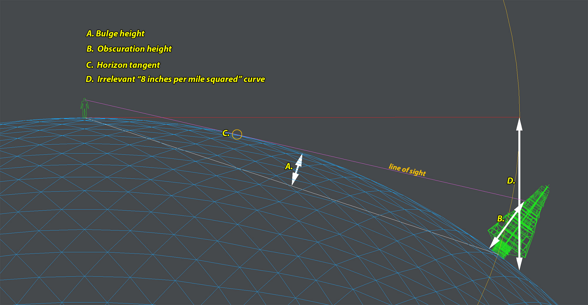
Only A and C are what I'm referring to in this picture.
bff854d857b13b86c3d099ae64a56fa9.jpg


Of course you wouldn't look down to see the horizon since it rises. Wouldn't you have to look down at the horizon for a flat earth since there is no bulge to raise it? On a fe are they suggesting line of sight/vanishing point raises the ground for the mid line horizon?

Also lol at discrediting NASA while using random youtubers for half of your arguments.

That map still can't explain known distances from say Sydney to Johannesburg, Buenos Aires and London. London is the furthest known out of those 3.

Find concrete proof, find the edge, prove the world wide conspiracy, disprove satellites, etc.

Ah, okay. And the atmosphere stays with us because of gravity although it is right next to a vacuum, correct?


As the story goes, this is a 1/2 truth. As you move farther from the earth, the spin increases massively. Like how we spin so much faster at the equator from everywhere else.


Irrelevant.


LOL


LOL, tell this stuff to @Higus and his pendulum.


Totally false as the plane is a closed, pressurized system. And it is flying through what we are told is a closed, pressurized system.


Yes, local conditions will show that, but this has NOTHING to do with the problem at hand.

Probably the reason for 5 layers of atmosphere with thinner and thinner air.

The spin of the atmosphere would be comparable to a windmill. Base is moving a significantly slower mph than the tips even though it's a straight line. It also explains the very frequent 100+ mph jet streams.

It's not irrelevant. If the plane and atmosphere are already moving before take off they will stay moving after take off.

Closed pressurized system, sound like an atmosphere no?

Very high wind caused by coriolis is irrelevant to air travel times?

Jet stream map from the 801 ground speed.

JET_STREAM_FLIGHT_AWARE.jpg
 
Last edited:
I honestly thought there'd be more... as God is my witness. Please, tell me there's more.

Well when you flat out reject things from the world's space/satellites companies like NASA, CNSA, etc...
 
You are thinking of the bulge from the perspective of it being on top of a flat plane. That isn't how it would be on a sphere. If you knew the equal point you'd have to look down towards the ground to "see" the 5 mile bulge. You aren't on flat ground then it rises up like a mountain...


Only A and C are what I'm referring to in this picture.
bff854d857b13b86c3d099ae64a56fa9.jpg
You don't get both ways (or more). Draw in the zed and take a peek.

Of course you wouldn't look down to see the horizon since it rises.
If the earth was a ball you would HAVE TO LOOK DOWN TO SEE THE HORIZON

This never happens... on the beach, 20 floors up in your building, on an airplane, or even over 120,000 feet on a balloon!

Find concrete proof, find the edge, prove the world wide conspiracy, disprove satellites, etc.
You make ridiculous claims, you need to prove that. Every experiment has show no curvature nor movement. NO EXPERIMENT EVER SHOWED OTHERWISE.

Probably the reason for 5 layers of atmosphere with thinner and thinner air.
Probably? Show me! Experimentally!

The spin of the atmosphere would be comparable to a windmill. Base is moving a significantly slower mph than the tips even though it's a straight line. It also explains the very frequent 100+ mph jet streams.
Show me! This is ridiculous you can even post this with no evidence. How do planes land on a fucking windmill?

Nothing on this thread is even close to backing the narrative and every attempt further discredits it.
 
Status
Not open for further replies.
Back
Top