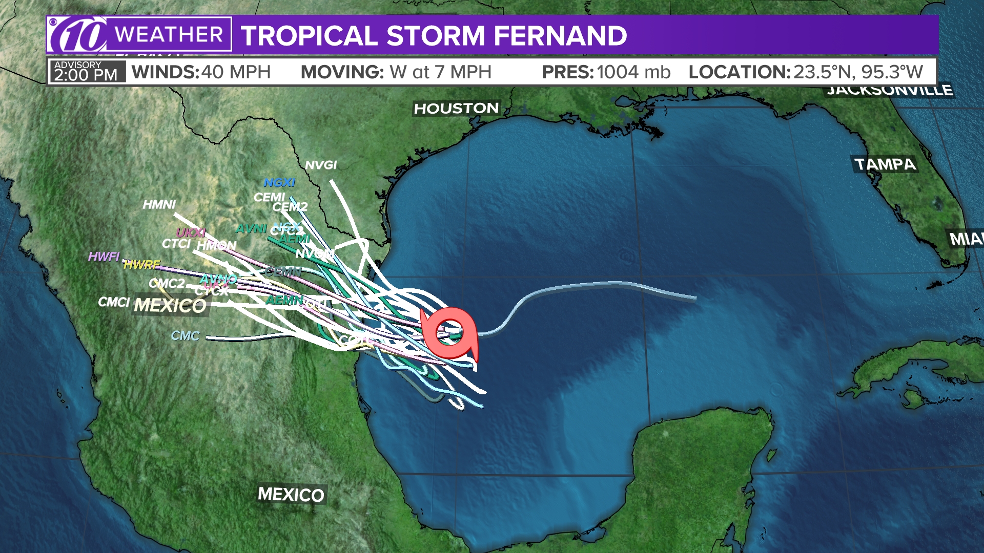
It just formed officially
Next 5 days or so it won't be so bad but I think it will get stronger as it makes it closer to us:
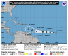
The area of low pressure located well south of the Cabo Verde
Islands now has a well-defined center and enough organized deep
convection to be considered a tropical cyclone. The initial
intensity is set to 35 kt based on data from recent ASCAT passes
that showed an area of 30-35 kt winds northwest of the center.
Kirk will be moving over SSTs around 27C for the next 36 hours or
so with generally low shear, which should allow for some gradual
strengthening. After that time, the SSTs increase quickly along the
forecast track, but the SHIPS model and global model fields show the
vertical shear increasing, in part due to the very fast low-level
easterly flow. In addition, the GFS and ECMWF global models don't
show much development of the cyclone during the forecast period. As
a result of these factors, little change in strength is forecast
after 48 hours. The NHC forecast is close to the HCCA consensus aid
through 48 hours and is near IVCN afterward.
The initial motion estimate is 280/12, but has the usual uncertainty
for a system in the early stages of development. The cyclone is
expected to be steered very quickly westward at low latitudes with
forward speeds reaching 20-25 kt over the next 72 hours to the south
of a mid-level ridge. Late in the period, some gain in latitude and
a slight decrease in forward speed are shown as a weakness in the
ridge develops to the east of the Lesser Antilles. The initial NHC
track forecast is close to HCCA and a little south of the TVCA
consensus, giving a little more weight to the GFS and ECMWF, which
lie on the south side of the track guidance envelope.
FORECAST POSITIONS AND MAX WINDS
INIT 22/1500Z 8.3N 23.6W 35 KT 40 MPH
12H 23/0000Z 8.8N 25.7W 40 KT 45 MPH
24H 23/1200Z 9.3N 29.6W 45 KT 50 MPH
36H 24/0000Z 9.4N 34.0W 50 KT 60 MPH
48H 24/1200Z 9.6N 38.6W 50 KT 60 MPH
72H 25/1200Z 10.3N 46.8W 50 KT 60 MPH
96H 26/1200Z 11.0N 53.0W 50 KT 60 MPH
120H 27/1200Z 12.5N 58.5W 45 KT 50 MPH