Law [Partisan Gerrymandering News] Florida appeals court reverses ruling on DeSantis’s congressional maps

California does this for the DNC don't they?

I know there are conservatives in California, although its totally hopeless for them.

No way you'll ever vote the Democrats outa there.

It started with republicans and in some areas democrats followed suit. It is mostly a republican thing but I hate it where ever it is. The federal government needs to do something about this because it is extremely undemocratic. It is complete bullshit just like the electoral system.
 
Don't the Dems do it too when they're in power ?

Not as much but yeah they do it to.

Pack all two latino districts together.

Illinois_District_4_2004.png


I don't even know what to say about this one.

lossless-page1-440px-Maryland_US_Congressional_District_3_%28since_2013%29.tif.png


HAHA YOU EX-MORMONS THOUGHT YOU COULD MOVE TO SALT LAKE CITY AND BE LIBERAL

440px-Utah%27s_2nd_congressional_district.gif
 
Someone developed a computer program that drew sensible voting boundaries based on preset criteria. Apparently it was a really fare and reasonable approach. Dems should shoot for this.
 
Gerrymandering in Texas: Why does this San Antonio district boundary look so bizarre?
Mark Dunphy | on October 27, 2020

rawImage.jpg

A San Antonio resident on the east side of Pleasanton Road does not share a U.S. House representative with their neighbor across the street.

Instead, that individual lives in the same congressional district as voters who live 95 miles away in North Austin.

Texas' 35th Congressional District sweeps up swaths of San Antonio's South and East Sides, snakes north along Interstate 35 — a narrow strip not much wider than the highway — then stretches to fit both Kyle and Lockhart before swallowing up several areas of Austin.

How did the district's boundaries end up resembling a stretched-out salamander?

After the 2010 census, the Republican-controlled Texas Legislature drew new electoral maps to account for the state's population growth.

The maps were immediately tied up in legal wrangling over claims they were unfair to Latino and Black voters, The Texas Tribune reported. Lawyers for the state argued that partisanship, not race, motivated the gerrymandering.

For the 2012 elections, a panel of three federal judges in San Antonio drew temporary maps, based largely on the Republican-drawn districts, which lawmakers formally adopted in 2013.

A 2017 court decision would eventually void three of the districts, including District 35.

The majority opinion said the district, held by U.S. Rep. Lloyd Doggett, was "improperly drawn with race as the predominant factor to minimize the number of Democratic districts and to attempt to unseat Doggett by boosting the Hispanic population, making it more likely that voters would choose a Latino candidate," according to the Austin American-Statesman.

The following year, the Supreme Court tossed out the challenges to District 35. The court's conservative majority sided with Texas lawyers who argued the state did not discriminate against voters of color in 2013 because lawmakers simply "embraced" maps approved by the lower court.

That conclusion to the seven-year court battle left the bizarre boundary intact. Next year, once the 2020 census is complete, the redistricting battle will start all over again.

https://www.expressnews.com/news/lo...ering-in-Texas-Why-does-this-San-15668213.php
 
Last edited:
Virginia’s new redistricting commission prepares to take applications from the public
By Gregory S. Schneider | November 27, 2020

imrs.php

RICHMOND — Beginning Monday, Virginians will have a month to apply for one of eight public seats on the state's new redistricting commission, which has begun its work with a panel of retired judges setting out plans for the application process.

Eight lawmakers will be named to the commission next week by General Assembly leaders. Once those lawmakers nominate members from the citizen applications, the full effort is scheduled to be up and running by Feb. 1.

This landmark new method for drawing political boundaries in Virginia was approved by voters on Nov. 3. The commission will face a compressed schedule next year to get new maps in place for the 2021 elections for governor, lieutenant governor, attorney general and all 100 seats in the House of Delegates.

Expected delays in the U.S. census data that guides the shaping of political boundaries could create a logjam: The federal government has promised to have the data available no later than April 1, but Virginia needs to have new maps in place by April 2 to stick to its usual schedule of primaries and elections, according to the state’s Division of Legislative Services (DLS).

That could lead the state to postpone the June primary until later in the year.

“The wild card is the census data. I think there are a lot of open questions out there about how that process will work,” said Kevin O’Holleran, spokesman for House Speaker Eileen Filler-Corn (D-Fairfax).

“That’s something the commission will take up as a first order of business,” said Amigo Wade, the director of DLS, which is staffing the effort.

In the meantime, application forms for citizen members are set to be posted online by Monday. The forms and more information about the process are available on the DLS website.

Under the constitutional amendment approved by voters, the commission will include eight lawmakers — two Republicans and two Democrats chosen by leaders of the House of Delegates, and two from each party chosen by Senate leaders. Those names are expected to be announced early next week.

Those members will review the citizen applicants and submit nominees to the panel of retired circuit court judges, who were chosen earlier this month by members of the General Assembly from a list supplied by Chief Justice Donald W. Lemons of the Supreme Court of Virginia.

That panel — whose four initial members selected retired Judge Pamela S. Baskervill of the Petersburg area as their fifth member and chairwoman — met for the first time on Wednesday via videoconference. They hashed out details of the application forms and made plans to reconvene in January to pick the eight citizen members from lawmakers’ lists. The public members are to be seated by Jan. 15.

The judges must consider the “racial, ethnic, geographic, and gender diversity of the Commonwealth” in making the selections, according to language passed by the General Assembly.

To be eligible, applicants must have been a Virginia resident and a registered voter for at least the past three years, and they must have voted in at least two of the past three elections.

Anyone who has held or run for political office; been employed by a campaign or officeholder; or who has been a registered lobbyist within the past five years will not be eligible to participate, nor will any of their close relatives.

The application form will include questions about education and work history, although there are no minimum requirements for eligibility.

All deliberations of the judges’ panel and the commission are to be open to the public. During Wednesday’s meeting, the judges adopted an emailed suggestion that the citizen application form ask broadly about education instead of including questions about college and postgraduate degrees, so it would not appear exclusionary.

The panel also approved an advertising plan to publicize the opportunity in newspapers and other media across the state.

“With step one of this process we already have more transparency than we’ve had in any redistricting cycle in Virginia history,” said Del. Schuyler T. VanValkenburg (D-Henrico), a leading advocate of the redistricting commission during this year’s legislative sessions.

Until now, the General Assembly has drawn political maps every 10 years, after each U.S. census. That tends to let the party in power secure its own future by designing friendly districts. But federal judges threw out parts of the 2011 map as racially gerrymandered, and the new system was billed as a way to take politics out of redistricting.

https://www.washingtonpost.com/loca...d6cad6-2f4b-11eb-860d-f7999599cbc2_story.html
 
Last edited:
Texas Democrats eye redistricting fights in state court as federal suits over gerrymandering mount
The Biden administration has joined the federal court fight. In two Texas state court cases, a group of lawmakers challenged the constitutionality of when and how Republicans drew the maps.
By Sami Sparber | Dec 16, 2021​

SPLJRPEVFZEJ3JG7HUCMVII72U.jpg

State Rep. NICOLE COLLIER, D-Fort Worth, speaks at the back mic while other representatives wait as the Texas House considers HB1, the chamber's redistricting plan, during a special session of the 87th Legislature.​


AUSTIN — As federal lawsuits over new political maps pile up, some Texas Democrats are focusing on a pair of state court cases, arguing this year’s GOP-led redistricting effort violated the Texas Constitution.

The Legislature’s GOP mapmakers in October passed new lines that cement Republicans’ grip on power for the next decade but blunt the voting strength of nonwhite voters who fueled Texas’ population surge.

In two cases heard Wednesday and Thursday, a group of mostly Democratic, Hispanic lawmakers from both chambers challenged the legality of when and how Republicans drew the boundaries.

“All we’re asking is for Republicans, who claim to be constitutionalists, to start acting like it, and follow the plain meaning and reading of the Constitution,” said Roland Gutierrez, one of two Democratic state senators who are suing Texas.

Focusing on the timing are Gutierrez and Sen. Sarah Eckhardt, who sued to block the Legislature from redistricting in a special session this year. Also at issue are rules for keeping counties intact when drawing Texas House districts.

Similar to a suit they filed in federal court before redrawing began, the senators’ attorneys argued the Texas Constitution requires that redistricting be done in a regular session that won’t happen until 2023.

That makes the newly drawn state House and state Senate plans invalid, argued the legal team for Gutierrez and Eckhardt, of San Antonio and Austin, respectively.

The senators’ lawyers pointed to a provision in the state Constitution that requires the redistricting process to start in the first regular session after the decennial Census has been published, asking the court to block the new plans from being used.

State lawyers argued the provision does not prohibit apportionment at other times, and warned that blocking the map will disrupt the 2022 election process that is already in motion.

“The Legislature … is perfectly free to redistrict whenever it wants,” Will Thompson, the attorney general’s deputy chief for special litigation, said at the Dec. 15 hearing in district court in Travis County.

All parties face a tight timeline for the March primaries. Overseas mail-in ballots are set to go out Jan. 15, and candidate filing ended Dec. 13.

But the court fights are not uncharted territory. The senators’ attorney, Wallace B. Jefferson, pointed out that for decades, every Texas redistricting plan has been either changed or tossed out by a federal court after being found in violation of the U.S. Constitution or the federal Voting Rights Act.

Texas argues “chaos will ensue if the court were to enjoin the maps, but the sky will not fall if that’s what the court decides,” said Jefferson, former Texas Supreme Court Chief Justice and Republican from San Antonio.

The consolidated cases have been assigned a panel of three district court judges, with Democrat Karin Crump presiding, alongside Republicans Emily Miskel and Ken Wise.

Splitting Cameron County
The senators’ legal team also argued the new state House map violated the “county line rule” of the Texas Constitution, which requires that counties with sufficient population be kept intact in drawing Texas House districts.

The second challenge, mounted by the Mexican American Legislative Caucus in the Texas House, made a similar case that the rule was broken, arguing it was designed to ensure people have local representation.

Both complaints focus on the redrawing of Cameron County in the Rio Grande Valley.

As lawmakers this fall debated the new House lines late into the night, they narrowly adopted a major change in South Texas. House District 37 was redrawn from a seat President Joe Biden won by 17 percentage points, to a seat the president won by only two points over former President Donald Trump in the 2020 election.

That amendment, developed by Kingsville Republican Rep. J.M. Lozano, was denounced by some Valley lawmakers. State Rep. Eddie Lucio III, D-Brownsville, called the change a “disingenuous, last-minute attempt to do a grab.”

The plaintiffs’ legal team argued the county line rule requires that two districts be wholly contained within Cameron County. Yet Lozano’s tweaks give Cameron County just one wholly contained district, with two that connect to adjoining counties.

The state’s lawyers argued the new boundaries do not dilute votes in Cameron County, and that Cameron got the number of districts it was constitutionally entitled to. The plaintiffs’ attorney rejected that interpretation of the rules.

“There is no doubt that to whatever extent Cameron County voters are a cohesive group … they get to elect the candidates of their choice,” said Thompson, one of the state’s lawyers.

District 37 Democratic candidate Ruben Cortez Jr. joined the senators’ suit, along with political organization Tejano Democrats. The new version of the district was joined with adjacent Willacy County.

“This Republican redistricting scheme is robbing the voice of Cameron County voters,” Cortez, also a member of the Texas State Board of Education, said in a news release.

The caucus’ complaint asked the court to block the Texas House map from being used in upcoming elections and allow for the creation of alternative boundaries. Both sides discussed a full trial beginning Jan. 10.

It’s unclear, if the judges rule in favor of the plaintiffs on the county line rule, whether they would delay Texas House primary elections just for South Texas, or the entire state. The plaintiffs’ legal team asked the court to delay the primary to May 24.

Thompson, the state lawyer, said he expects the 2023 Legislature to have to revisit the maps.

In a separate federal suit, MALC has argued the redrawn congressional, Texas House and State Board of Education maps are intentionally racially discriminatory and dilute Latino voting strength, in violation of the federal Voting Rights Act and U.S. Constitution.

The U.S. Department of Justice has joined the federal court fight, suing to block Texas’ gerrymandered congressional and state House maps. Several civil and voting rights groups, as well as individual voters, are among the plaintiffs in the consolidated federal redistricting cases.

Court challengers say the redrawn congressional, legislative and State Board of Education maps do not reflect the major growth of the Hispanic community, which made up nearly half of the state’s population gain since 2020. People of color accounted for 95% of the state’s population boom over the last decade, with much of the growth concentrated in cities and suburban areas, census data show.

In the plan for state House elections, the number of majority-white seats increased from 83 to 89, among eligible voters. The number of majority-Hispanic districts grew from 33 to 30, and the number of majority-Black districts dropped from seven to six. Asian voters remain without majority control in any district.

The decennial process following a U.S. Census typically leads to lawsuits in Texas, with the courts largely siding with Republicans in recent years. Lawmakers can draw maps in a way that benefits their party’s political future as long as they do not discriminate on the basis of race.

This year, Republican lawmakers have a clearer path toward using the lines they want, as Texas is no longer required to get federal approval on new political maps.

The new maps are generally expected to withstand lawsuits, but battles over aspects of the boundaries could last several years.

https://www.dallasnews.com/news/pol...t-as-federal-suits-over-gerrymandering-mount/
 
In Nevada, gerrymandering claims come from all sides
The Silver State is one of the only swing states where Democrats have full control over the redistricting process. But it’s not just Republicans who are crying foul.
By Nate MacKay / December 15, 2021

nevada-redistricting-map-1452x1880.jpg

A map of Nevada's congressional district as drawn by the Legislature and approved by the governor in November 2021.


RENO, Nev. (CN) — Democrats in Nevada are facing claims of gerrymandering from the left, right and center after redistricting the Legislature and its four Congressional seats.

A contentious and consequential special legislative session ended Nov. 16 with the passage of Senate Bill 1, finalizing the Silver State’s district maps for the next decade. Every Republican and one Democrat voted no, and the GOP decried the bill as a Democratic power grab. Of the 15 states where the 2020 presidential election fell within a 10-point margin, Nevada is the only one where Democrats have the governorship, majorities in the Legislature and complete redistricting control.

“What’s hurting Democrats is they’re trying to say because there are fewer blue states gerrymandering, ‘We don’t gerrymander, it’s just the Republicans,’” said Sondra Cosgrove, executive director of Vote Nevada and history professor at College of Southern Nevada. “We are gerrymandering just as bad. It’s just easy not to pay attention to us because you’ve got Texas, North Carolina and Ohio, which are huge gerrymandering cases.”

Adam Podowitz-Thomas, senior legal analyst from the Princeton Gerrymandering Project, said there was a “good possibility” that gerrymandering suits could be filed in all 50 states.

“This is going to be perhaps the most highly litigated redistricting cycle we’ve ever seen,” Podowitz-Thomas said. “It’s going to be a lot on the courts and judges to figure out.”

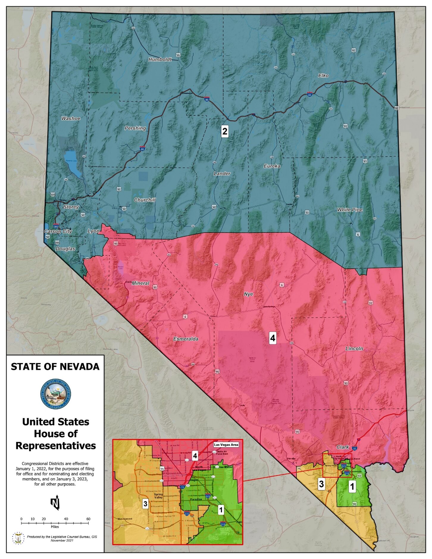
On Nov. 17, two Republicans from sprawling Nye County sued claiming partisan gerrymandering violates the state’s voter bill of rights. The Republican plaintiffs, Assemblyman Gregory Hafen and former county commissioner John Koenig, claim the districts were designed to weaken rural voters’ influence outside the more populous Clark and Washoe counties. The new map splits Pahrump, the conservative Nye County seat, and divides the ruby-red county into three different Assembly districts.

“I think the case that’s being made is strong,” said Doug Goodman, director of Nevadans for Election Reform. “[The Legislature] definitely split communities of interest by depriving the rural residents of Nye County a chance of having somebody elected and represent them in the Legislature. No question, [the maps] are partisan gerrymanders.”

Requests for comment sent to the plaintiffs in the lawsuit and multiple members of the Legislature went unanswered. But Goodman voiced concern about the Legislature’s largely unfettered control over redistricting, saying it allows their power and influence to expand and disregards Nevada’s growing nonpartisan voting bloc.

According the Princeton Gerrymandering Project and FiveThirtyEight, Nevada’s new congressional map has one Republican-leaning seat and three that lean slightly Democratic which are currently held by Democrats. A once solid-blue district was divided, ostensibly to shore up support for the Democrats facing tough reelection fights in 2022.

Podowitz-Thomas explained Nevada’s maps aren’t “durable” like many partisan gerrymanders are.

“The Democratic Party gave itself such small majorities in the three districts they’re going to control that it’s a risky proposition for them over the next decade,” Podowitz-Thomas said, noting all four congressional seats could feasibly go to Republicans during a strong GOP election.

Several Latino groups from Clark County’s liberal core fiercely opposed the maps.

Cosgrove said her predominantly working-class, Latino neighborhood in east Las Vegas is rife with frustration. She said their new congressional district will no longer have a racially diverse, working-class electorate of the “same socioeconomic strata.” Instead, the Democrats “blew up their base,” splintering the once solid-blue district and adding many white, wealthier communities.

“If I was a Democrat, I would be secretly praying the court came in and overturned [the maps],” Cosgrove said, noting the anger within communities of color regarding redistricting. “If these maps stay, [Democrats] could face losing just because people are mad at them and don’t show up.”

Cosgrove said the Legislature's reduction of the Latino population from about 46% to 32% in the district split voters with similar working-class interests and ignored their requests to be packed together to choose candidates who represent those collective interests.

Nevadans Count, a coalition of organizations advocating for fair redistricting, also lobbied against fragmenting the predominantly Latino congressional district and proposed alternative maps.

“It puts pretty different income levels in the same district,” Noé Orosco, spokesperson for Silver State Voices and Nevadans Count, said of the cities now grouped into the same district. “With those cities, whenever they are asking or advocating for some funding, they could potentially be putting each other at odds.”

Orosco said the final maps were “not the result we were hoping for.” He said the coalition was “monitoring any anything related to redistricting in the state of Nevada,” including the ongoing legal battles, but had not decided whether to bring a racial gerrymandering suit. Orosco was unaware of any Latino groups within the coalition being approached to join the Republicans’ lawsuit.

Cosgrove said the Democrat-controlled Legislature had also tried to split the solid blue district between the wealthier, white suburban districts during 2011’s redistricting. Those maps were twice vetoed by then-Governor Brian Sandoval, a Republican and former federal judge.

With no maps, Judge James Russell appointed special masters to redraw the maps utilizing public feedback. Cosgrove noted Russell is now the judge assigned to the Nye County Republicans’ suit. She expects a similar outcome given how similar the Legislature’s maps are now to the ones rejected a decade ago.

Podowitz-Thomas said “intrinsically, the map-drawing process is one of trade-offs,” but a necessary aspect of drawing fair maps “is that communities have the opportunity to have feedback on the map and that feedback was taken seriously.”

The Legislature did, however incorporate feedback from the Indigenous community. Tammi Tiger, civic engagement program consultant with the Las Vegas Indian Center, testified against proposals dividing some tribal lands and reservations into different districts. When the revised maps kept the Indigenous communities intact, Tiger said the tribes and tribal citizens were “very excited and appreciative.”

“For Indigenous people, the people and the land are synonymous. The land is sacred to us,” Tiger said. “It’s still important that any decisions that are made to tribal lands, we have one elected representative to go to.”

Tiger and Orosco both said a public meeting regarding redistricting should be held on every tribal land to set a precedent honoring the government-to-government relationship with tribes.

“A lot of our tribes are rural,” Tiger explained. “They’re not going to drive two hours when they’ve got kids to take care of and obligations to meet, so being able to host those on tribal lands would be much more effective at [getting] their input.”

Governor Steve Sisolak praised the Legislature’s consideration of public feedback in a statement issued after he signed the maps into law.

“These maps reflect Nevada’s diversity and reflect public feedback gathered throughout the legislative process,” said Sisolak. Cosgrove blasted the response.

“Dude, are you smoking something? No one testified in favor of the maps. When it came time for opposition, it was two hours of people explaining why they hated the maps,” Cosgrove said, noting the dissenters included people of color, rural voters, conservatives and more.

Cosgrove, Goodman and Podowitz-Thomas all agree single-party control of redistricting exacerbates gerrymandering risks. But Cosgrove said Nevada’s “bigger problem” is the Legislature exempting itself from open-meeting laws, muddying the waters of the process.

“If you’ve got a Legislature refusing to tell us who drew the maps, refusing to tell us justifications for why they drew the maps the way they did, there’s absolutely no way to fix this process,” said Cosgrove.

Goodman and Cosgrove advocate for an independent redistricting commission. Last week, Cosgrove filed an initiative for a 2022 ballot question that could allow voters to strip the redistricting power from the Legislature and place Republicans, Democrats and independents on a commission subject to open-meeting laws and higher redistricting standards.

“I’m not assuming people are going to sing and hold hands and draw a map. You can fight it out all you want, but it just needs to be very transparent,” Cosgrove said. “We just want to be there while you’re doing it and have a say.”

Podowitz-Thomas said court-mandated maps and independent commissions are generally much fairer than legislators. But he warned commissions staffed by many politicians can still gerrymander.

“In Ohio, they drew a map and it was a partisan gerrymander. In Virginia, where half the commission was made up of politicians, they failed to draw a map at all and it went to the state Supreme Court to hire special masters,” Podowitz-Thomas said.

But Goodman and Cosgrove voiced confidence that redistricting reforms have the popular support in Nevada and elsewhere to pass via ballot initiative.

“I think the ‘we the people’ part of the Constitution is going to roar up on its hind legs and take a swat at the political parties,” Cosgrove said.

https://www.courthousenews.com/in-nevada-gerrymandering-claims-come-from-all-sides/
 
Last edited:

Florida appeals court reverses ruling on DeSantis’s congressional maps

BY NICK ROBERTSON - 12/01/23

A state appeals court in Florida reaffirmed Gov. Ron DeSantis’s (R) congressional maps Friday, reversing a lower court ruling that labeled them unconstitutional.

The appeals court said the lower court misapplied precedent, and that the suit challenging the maps should have been dismissed.

At the center of the legal conflict are the Florida Constitution’s Fair Districts Amendments, passed in 2010, which restrict partisan gerrymandering.

A 2015 Florida Supreme Court case ruled that state Republicans violated the amendments in their 2010 congressional maps, focusing on districts surrounding Jacksonville, leading the court to force a new set of district boundaries.

DeSantis proposed a new set of maps in January 2022, which again faced legal challenges based on the Fair Districts Amendments. Plaintiffs said the governor and Florida Republicans drew the lines to reduce the voting power of Black voters in Jacksonville by splitting the city between multiple districts.

The lower court threw out these maps in September — citing the 2015 Florida Supreme Court case. But the appeals court decided Friday that the case was not binding precedent and should not have been relied upon, instead leaning on other factors.

The state’s 5th District is at the center of the case. The pre-2020 census district spanned from parts of Tallahassee across the Florida-Georgia border to Jacksonville, while the DeSantis version of the district would instead include a tightly-packed section of parts of Jacksonville and its southeastern suburbs, moving down the coast to St. Augustine.

The old 5th District had a Black population of about 46 percent, while the new district is just 12.8 percent Black — with the remaining Black population split across other districts with significantly fewer Black voters than the previous district.

The lower court ruled in September that the new maps “diminish [the] ability [of a racial minority] to elect representatives of their choice.” But in Friday’s opinion, the appellate court ruled that is not the case.

The appeals court said the lower court “simply relied on the mere existence of the former [5th District] as a Black performing district as a basis for using it as a benchmark,” instead of considering the Black communities of Tallahassee and Jacksonville separately, for the purposes of redistricting.

“There was no evidentiary basis for the conclusion that [the 5th District] afforded a legally cognizable Black community,” Judges Brad Thomas and Adam Tanenbaum wrote in the majority opinion.

The ruling means that all of North Florida’s congressional districts — all of which are held by Republicans — will remain in effect for the 2024 elections unless the case is again overturned by the Florida Supreme Court.

Genesis Robinson, political director for activist group Equal Ground and a plaintiff in the case, denounced the decision Friday.

“Today’s ruling by the First District Court of Appeals sets a dangerous precedent for the erosion of voting rights in Florida,” he said in a statement.

“From the very beginning, Gov. DeSantis has been using the voting rights of Black Floridians as pawns in his game of political ambition. When voters overwhelmingly passed the Fair District Amendments in 2010, this was the very type of political corruption and partisan favoritism they sought to rid from our state,” he continued.

Robinson said plaintiffs expect to appeal the case to the state Supreme Court.

 
Back
Top